
Bulgarian regions, cities and towns
Information and properties for sale in cities and towns in Bulgaria
Here you will find all the necessary information to make your best Bulgarian property investment! We have prepared for you detailed information plus pictures of all cities, regions and towns in Bulgaria where we offer excellent properties for sale. There are three important factors to look for in order to make a wise property purchase: location, location and location :). You can now easily choose the best location for your Bulgarian property!
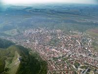
Razgrad
The town of Razgrad has a population of 39 036 inhabitants. It is about 200 m above sea-level and is situated on the Loudogorie plateau. The town is considered the capital of the Loudogorie, on either bank of the Beli Lom River. Razgrad is 375 km north-east of Sofia, 66 km south-east of Rousse, 49 km north-west of Shoumen, 36 km north of Turgovishte, 36 km north-east of Popovo and 108 km south-west of Silistra. History: Razgrad is the successor of the Roman settlement called Abritus (its...
The town of Razgrad has a population of 39 036 inhabitants. It is about 200 m above sea-level and is situated on the Loudogorie plateau. The town is considered the capital of the Loudogorie, on either bank of the Beli Lom River. Razgrad is 375 km north-east of Sofia, 66 km south-east of Rousse, 49 km north-west of Shoumen, 36 km north of Turgovishte, 36 km north-east of Popovo and 108 km south-west of Silistra. History: Razgrad is the successor of the Roman settlement called Abritus (its...
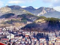
Razlog
The town of Razlog has a population of 13 403 inhabitants and is 825 m above the sea level. It is located in the Razlozhka Valley, in the hug of 3 mountains - Rila to the north, Pirin to the south and the Rhodopes to the east. It is nestled among two hills - Golak to the north and Sarovitsa to the south. Nearby flows Mesta River. The town is 155 km to the south of Sofia, 53 km to the south-west of Blagoevgrad, 141 km south-west of Plovdiv and 6 km north of Bansko. The past of Razlog to...
The town of Razlog has a population of 13 403 inhabitants and is 825 m above the sea level. It is located in the Razlozhka Valley, in the hug of 3 mountains - Rila to the north, Pirin to the south and the Rhodopes to the east. It is nestled among two hills - Golak to the north and Sarovitsa to the south. Nearby flows Mesta River. The town is 155 km to the south of Sofia, 53 km to the south-west of Blagoevgrad, 141 km south-west of Plovdiv and 6 km north of Bansko. The past of Razlog to...
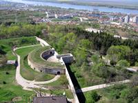
Ruse
The town of Ruse has 162 128 inhabitants and is on 50 metres above sea level. It is located on the high right bank of the Danube River, 496 m from the outflow of the big river. It is 320 km north-east of Sofia, 203 km north-west of Varna, 106 km north-east of Veliko Turnovo, 146 km north-east of Pleven, 97 km north-east of Svishtov, 122 km south-west of Silistra, 66 km north-west of Razgrad. The greatest and the most important Bulgarian town on the Danube River, known also as ?Little Vienna?...
The town of Ruse has 162 128 inhabitants and is on 50 metres above sea level. It is located on the high right bank of the Danube River, 496 m from the outflow of the big river. It is 320 km north-east of Sofia, 203 km north-west of Varna, 106 km north-east of Veliko Turnovo, 146 km north-east of Pleven, 97 km north-east of Svishtov, 122 km south-west of Silistra, 66 km north-west of Razgrad. The greatest and the most important Bulgarian town on the Danube River, known also as ?Little Vienna?...
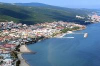
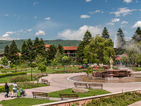
Saint Vlas
The resort Saint Vlas has a population of 3000 people. It is located on the shore of the Black Sea Coast and in the foot of the south slopes of the east Stara Planina mountain. The settlement is located in a close proximity to the town of Bourgas - 40 km, Nessebar - 8 km, Sunny Beach - 4 km, Paradise Beach - 1,5 km, Elenite 2km. Watch a 4k drone video of the beach resort Saint Vlas: Saint Vlas was found in the II century as a Thracian settlement with the name Larisa,...
The resort Saint Vlas has a population of 3000 people. It is located on the shore of the Black Sea Coast and in the foot of the south slopes of the east Stara Planina mountain. The settlement is located in a close proximity to the town of Bourgas - 40 km, Nessebar - 8 km, Sunny Beach - 4 km, Paradise Beach - 1,5 km, Elenite 2km. Watch a 4k drone video of the beach resort Saint Vlas: Saint Vlas was found in the II century as a Thracian settlement with the name Larisa,...
Samokov
The town of Samokov has a population of 27 664 inhabitants and is 950 m above sea level. It is situated in the northern foot of Rila Mountain in the field of the same name, which is the highest in Bulgaria. The longest Bulgarian River Iskar, springing from Rila, flows through it. It is situated 60 km south-east of Sofia, 40 km east of Doupnitsa, 36 km south-west of Ihtiman, 37 km west of Kostenets and 12 km north-west of Borovets Resort. There are 6 more resorts in the region, 2 of them...
The town of Samokov has a population of 27 664 inhabitants and is 950 m above sea level. It is situated in the northern foot of Rila Mountain in the field of the same name, which is the highest in Bulgaria. The longest Bulgarian River Iskar, springing from Rila, flows through it. It is situated 60 km south-east of Sofia, 40 km east of Doupnitsa, 36 km south-west of Ihtiman, 37 km west of Kostenets and 12 km north-west of Borovets Resort. There are 6 more resorts in the region, 2 of them...
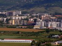
Sandanski
The town of Sandanski has population of 26 695 and is 240 m above sea level. It is situated in South-Western Bulgaria, right next to the west of the Pirin Mountain, along the banks of the Sandanska Bistritsa River which shortly after passing the town flows into the Struma River. Sandanski is 23 km north-east of Petrich, 22 km north of Kulata, the border checkpoint with Greece, 65 km south of Blagoevgrad and 166 km north of Sofia. The area of Sandanski has the best climate in the whole...
The town of Sandanski has population of 26 695 and is 240 m above sea level. It is situated in South-Western Bulgaria, right next to the west of the Pirin Mountain, along the banks of the Sandanska Bistritsa River which shortly after passing the town flows into the Struma River. Sandanski is 23 km north-east of Petrich, 22 km north of Kulata, the border checkpoint with Greece, 65 km south of Blagoevgrad and 166 km north of Sofia. The area of Sandanski has the best climate in the whole...
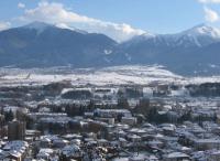
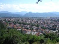
Sapareva Banya
The town of Sapareva Banya is located in Western Bulgaria, 70 km south of Sofia and 55 km east of Kyustendil. The city population is 3800 people. The city is located below the northern slopes of the Rila Mountains, at 750 meters above sea level. The E-79 international highway passes near the city, facilitating transport links in the region. The climate here is transitional continental. The average monthly temperature in January is 0 degrees and in July it is +22 degrees. Sapareva...
The town of Sapareva Banya is located in Western Bulgaria, 70 km south of Sofia and 55 km east of Kyustendil. The city population is 3800 people. The city is located below the northern slopes of the Rila Mountains, at 750 meters above sea level. The E-79 international highway passes near the city, facilitating transport links in the region. The climate here is transitional continental. The average monthly temperature in January is 0 degrees and in July it is +22 degrees. Sapareva...
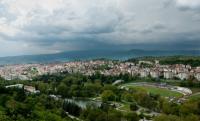
Sevlievo
Sevlievo is located in central northern Bulgaria, Gabrovo region. The administrative center of Sevlievo is located near the geographic center of the country, 178 km east of the capital Sofia.The municipality is 1070 sqkm. Settlements are a total of 53, Sevlievo and 52 administrative villages structured in 15 with mayors and 15 villages with deputy mayors. The population of the municipality is about 44,500, of which 27,500 live in the city and 17,000 in the villages. The altitude of the...
Sevlievo is located in central northern Bulgaria, Gabrovo region. The administrative center of Sevlievo is located near the geographic center of the country, 178 km east of the capital Sofia.The municipality is 1070 sqkm. Settlements are a total of 53, Sevlievo and 52 administrative villages structured in 15 with mayors and 15 villages with deputy mayors. The population of the municipality is about 44,500, of which 27,500 live in the city and 17,000 in the villages. The altitude of the...
Shumen
The town of Shumen has a population of 89 054 and is 220 m above sea-level. It is situated at the eastern mouth of the Shumen Plateau, on either bank of the Bokloudga river. The town is 380 km north-east of Sofia, 115 km south-east of Ruse, 90 km west of Varna, 140 km north-east of Veliko Tarnovo, 41 km east of Targovishte, 49 km south-east of Razgrad, 113 km south of Silistra, and 56 km north-east of Vurbitsa. History & Landmarks History: Shumen is an old town of fortresses. Its...
The town of Shumen has a population of 89 054 and is 220 m above sea-level. It is situated at the eastern mouth of the Shumen Plateau, on either bank of the Bokloudga river. The town is 380 km north-east of Sofia, 115 km south-east of Ruse, 90 km west of Varna, 140 km north-east of Veliko Tarnovo, 41 km east of Targovishte, 49 km south-east of Razgrad, 113 km south of Silistra, and 56 km north-east of Vurbitsa. History & Landmarks History: Shumen is an old town of fortresses. Its...
Silistra
The town of Silistra has a population of 42 153 and is 20 m above sea-level. It is situated on the right bank of the river Danube, on 375th kilometres away from the river mouth, at the point where the river enters the territory of Romania and the terrestrial boundary between Bulgaria and Romania begins. It is 442 km and 122 km north-east of Sofia and Rousse respectively, 108 km north-east of Razgrad, 113 km north of Shoumen, and 92 km and 143 km north-west of Dobrich and Varna respectively....
The town of Silistra has a population of 42 153 and is 20 m above sea-level. It is situated on the right bank of the river Danube, on 375th kilometres away from the river mouth, at the point where the river enters the territory of Romania and the terrestrial boundary between Bulgaria and Romania begins. It is 442 km and 122 km north-east of Sofia and Rousse respectively, 108 km north-east of Razgrad, 113 km north of Shoumen, and 92 km and 143 km north-west of Dobrich and Varna respectively....
Sliven
The town of Sliven has a population of 100 695 and is 270 m above sea level. It is situated in the eastern part of the Gornotrakiyska Lowland at the foothills of the Sliven Balkan. The tow is situated on 279 km east of Sofia, 28 km north-west of Yambol, 70 km north-east of Stara Zagora and 114 km west of Bourgas. Most probably the name derives from the location of the town, i.e. fusion of the field, the mountain and the three rivers of Assenovska, Selishka and Novo-sselska (?slivam? ?...
The town of Sliven has a population of 100 695 and is 270 m above sea level. It is situated in the eastern part of the Gornotrakiyska Lowland at the foothills of the Sliven Balkan. The tow is situated on 279 km east of Sofia, 28 km north-west of Yambol, 70 km north-east of Stara Zagora and 114 km west of Bourgas. Most probably the name derives from the location of the town, i.e. fusion of the field, the mountain and the three rivers of Assenovska, Selishka and Novo-sselska (?slivam? ?...
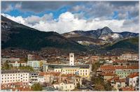
Smolyan
The town of Smolyan has 33 153 inhabitants and is 850 to 1050 m above sea level. It is picturesquely scattered in the narrow gorge of Cherna River (Black River), in the most beautiful part of the Rhodope Mountains. It is about 260 km south-east of Sofia, 103 km south of Plovdiv, 87 km west of Kurdzhali, 46 km south-east of Devin and 16 km south of Pamporovo Resort. This is one of the most beautiful Bulgarian towns and a regional administrative centre. On the 18th of June, 1960 the three...
The town of Smolyan has 33 153 inhabitants and is 850 to 1050 m above sea level. It is picturesquely scattered in the narrow gorge of Cherna River (Black River), in the most beautiful part of the Rhodope Mountains. It is about 260 km south-east of Sofia, 103 km south of Plovdiv, 87 km west of Kurdzhali, 46 km south-east of Devin and 16 km south of Pamporovo Resort. This is one of the most beautiful Bulgarian towns and a regional administrative centre. On the 18th of June, 1960 the three...
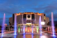
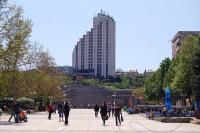
Sofia
The capital of the Republic of Bulgaria is the city of Sofia. It has 1 096 389 inhabitants and is on 550 metres above sea level. The city lies in the Sofia Plain, enclosed by the Balkan Mountains to the north, the Lozen Mountain to the southeast, Mountain Vitosha to the south, the Lyulin Mountain to the southwest. The plain is open to the northwest in the direction of Yugoslavia, and to the southeast to the Thracian Lowland. Sofia is situated 55 km from the Yugoslav border at Kalotina...
The capital of the Republic of Bulgaria is the city of Sofia. It has 1 096 389 inhabitants and is on 550 metres above sea level. The city lies in the Sofia Plain, enclosed by the Balkan Mountains to the north, the Lozen Mountain to the southeast, Mountain Vitosha to the south, the Lyulin Mountain to the southwest. The plain is open to the northwest in the direction of Yugoslavia, and to the southeast to the Thracian Lowland. Sofia is situated 55 km from the Yugoslav border at Kalotina...