
Bulgarian regions, cities and towns
Information and properties for sale in cities and towns in Bulgaria
Here you will find all the necessary information to make your best Bulgarian property investment! We have prepared for you detailed information plus pictures of all cities, regions and towns in Bulgaria where we offer excellent properties for sale. There are three important factors to look for in order to make a wise property purchase: location, location and location :). You can now easily choose the best location for your Bulgarian property!
Ihtiman
The municipality is located in Ihtiman valley over an area of 515 854 sq ², 52 km southeast of Sofia. These lands were inhabited since the Eneolithic. It is a place of advanced culture since antiquity, as evidenced by archaeological finds - chromes, coins, pieces of pottery and furnaces for melting metal in the area Yazovinite. In these lands passes the road from Belgrade to Constantinople. The passes at Vakarel and Trajnovi vrata are important strategic points. Ichtiman name occurs after...
The municipality is located in Ihtiman valley over an area of 515 854 sq ², 52 km southeast of Sofia. These lands were inhabited since the Eneolithic. It is a place of advanced culture since antiquity, as evidenced by archaeological finds - chromes, coins, pieces of pottery and furnaces for melting metal in the area Yazovinite. In these lands passes the road from Belgrade to Constantinople. The passes at Vakarel and Trajnovi vrata are important strategic points. Ichtiman name occurs after...
Kameno
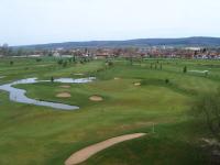
On 354.7 square kilometers in the fertile Bourgas valley is located Municipality of Kameno. Its administrative center Kameno city is 20 km away from Bourgas. Kameno borderes to the east with the municipality of Burgas, on the west with the municipality of Karnobat, north with the municipality Aytos and to the south with the municipality of Sredets. The area is situated in lowland southeastern Bulgaria, on the lower course of the river Aytoska. Its altitude is 20 to 45 meters. Major...
On 354.7 square kilometers in the fertile Bourgas valley is located Municipality of Kameno. Its administrative center Kameno city is 20 km away from Bourgas. Kameno borderes to the east with the municipality of Burgas, on the west with the municipality of Karnobat, north with the municipality Aytos and to the south with the municipality of Sredets. The area is situated in lowland southeastern Bulgaria, on the lower course of the river Aytoska. Its altitude is 20 to 45 meters. Major...
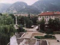
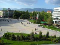
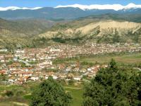
Karlovo
The town of Karlovo has 25 715 inhabitants and is 520 metres above sea level. It is situated in the valley of the same name, which is part of the famous Rose Valley, along the two banks of Stara Reka River, left feeder of Stryama River. The town is located 141 km east of Sofia, 58 km north of Plovdiv, 55 km west of Kazanluk, 66 km south of Troyan, 5 km east of Sopot and 17 km west of Kalofer. It is the birthplace of the greatest Bulgarian - The Apostle of Freedom Vassil Levski. History:...
The town of Karlovo has 25 715 inhabitants and is 520 metres above sea level. It is situated in the valley of the same name, which is part of the famous Rose Valley, along the two banks of Stara Reka River, left feeder of Stryama River. The town is located 141 km east of Sofia, 58 km north of Plovdiv, 55 km west of Kazanluk, 66 km south of Troyan, 5 km east of Sopot and 17 km west of Kalofer. It is the birthplace of the greatest Bulgarian - The Apostle of Freedom Vassil Levski. History:...

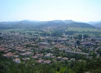
Karnobat
Municipality Karnobat is located in South-East Bulgaria and is part of the administrative district Burgas. The Rishki Pass connects the municipality with North Bulgaria. In the north part of the municipalities territories is located the Karnobat- Aitos section of Stara Planina Mountain. South from Karnobat are the Hissar Hills. Historic data shows that the town has been administrative center since XV century. It was an important agricultural and commercial center with traditional annual...
Municipality Karnobat is located in South-East Bulgaria and is part of the administrative district Burgas. The Rishki Pass connects the municipality with North Bulgaria. In the north part of the municipalities territories is located the Karnobat- Aitos section of Stara Planina Mountain. South from Karnobat are the Hissar Hills. Historic data shows that the town has been administrative center since XV century. It was an important agricultural and commercial center with traditional annual...
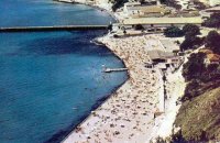
Kavarna
Kavarna has a population of 12 225 and is situated 48 km north of Varna, 518 km north-east of Sofia and 12 km away from Cape Kaliakra. It is a Black Sea port for passenger and cargo vessels of medium type. Kavarna is the successor of the Thracian settlement called Bizone, the earliest finds dating back to the end of 6th century BC. Later on Greek settlers came here and turned it into one of the numerous Greek colonies along the Black Sea coast. In 1st century BC the town suffered severe...
Kavarna has a population of 12 225 and is situated 48 km north of Varna, 518 km north-east of Sofia and 12 km away from Cape Kaliakra. It is a Black Sea port for passenger and cargo vessels of medium type. Kavarna is the successor of the Thracian settlement called Bizone, the earliest finds dating back to the end of 6th century BC. Later on Greek settlers came here and turned it into one of the numerous Greek colonies along the Black Sea coast. In 1st century BC the town suffered severe...
Kazanlak
Kazanluk has 54 021 inhabitants and is 350 m above sea level. It is a town located in the centre of the valley bearing the same name, whose eastern part is known beyond the boundaries of Bulgaria as the Valley of the Roses. It is about 200 km east of Sofia, 55 km east of Karlovo, 48 km south of Gabrovo, 75 km west of Sliven, 35 km north-west from Stara Za-gora and 108 km north-east of Plovdiv. Kazanluk is an important industrial, historical and cultural centre. The town is the capital of...
Kazanluk has 54 021 inhabitants and is 350 m above sea level. It is a town located in the centre of the valley bearing the same name, whose eastern part is known beyond the boundaries of Bulgaria as the Valley of the Roses. It is about 200 km east of Sofia, 55 km east of Karlovo, 48 km south of Gabrovo, 75 km west of Sliven, 35 km north-west from Stara Za-gora and 108 km north-east of Plovdiv. Kazanluk is an important industrial, historical and cultural centre. The town is the capital of...
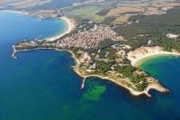
Kiten
The village of Kiten has a population of 528. It is situated at the south end of Primorsko Bay, 56 km south of Bourgas and 446 south-east of Sofia. The village is the successor of the Urdoviza Fortress situated on the cape itself. The Romans called the settlement Oroudiza. The town existed till the fall under Turkish domination and after that it was abandoned. One can still see ruins of the settlement lying on the cape. The river of Karaagach is very beautiful; it flows into the sea...
The village of Kiten has a population of 528. It is situated at the south end of Primorsko Bay, 56 km south of Bourgas and 446 south-east of Sofia. The village is the successor of the Urdoviza Fortress situated on the cape itself. The Romans called the settlement Oroudiza. The town existed till the fall under Turkish domination and after that it was abandoned. One can still see ruins of the settlement lying on the cape. The river of Karaagach is very beautiful; it flows into the sea...
Kostenets
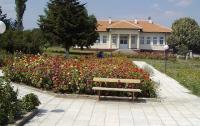
The municipality of Kostenets is located in South-West Bulgaria and is part of the Sofia district.. The municipality is 74 km to the south-east from the Bulgaria's capital - Sofia and is about 80 km away from the second biggest city in Bulgaria - Plovdiv. The adjacent municipalities are Dolna Banya, Belovo, Yakoruda, Ihtiman, Lesichovo and Septemvri municipalities. Trough the territory of the municipality is passing a section of the Trakya highway connecting Sofia and Bourgas. The...
The municipality of Kostenets is located in South-West Bulgaria and is part of the Sofia district.. The municipality is 74 km to the south-east from the Bulgaria's capital - Sofia and is about 80 km away from the second biggest city in Bulgaria - Plovdiv. The adjacent municipalities are Dolna Banya, Belovo, Yakoruda, Ihtiman, Lesichovo and Septemvri municipalities. Trough the territory of the municipality is passing a section of the Trakya highway connecting Sofia and Bourgas. The...
Kostinbrod
The town is located 16 km north- west of Sofia in Sofia valley. Two rivers pass through it - in the north of the River Blato, and in the south - Belitza River and two small tributaries of the Iskar River. According to the legend Kostinbrod was founded by a man named Costa , who long ago settled to the ford in the river Belitza (now at the entry into the city from Sofia). There he made a roadside pub and the place became a favorite for many traders arriving in the capital. People began...
The town is located 16 km north- west of Sofia in Sofia valley. Two rivers pass through it - in the north of the River Blato, and in the south - Belitza River and two small tributaries of the Iskar River. According to the legend Kostinbrod was founded by a man named Costa , who long ago settled to the ford in the river Belitza (now at the entry into the city from Sofia). There he made a roadside pub and the place became a favorite for many traders arriving in the capital. People began...
Kresna
Kresna municipality is located in southwestern Bulgaria and is one of the municipalities of Blagoevgrad district. The municipality has seven places from which one town (Kresna) and six villages: Vlahi,Gorna Breznitsa, Dolna Gradeshnitsa, Slivnitza, Stara Kresna and Oshtava. The total population is 6062 inhabitants. Kresna municipality (344 sq km) is located in southwestern Bulgaria and has an important transportation and geographical position. Here lies the shortest route from the capital...
Kresna municipality is located in southwestern Bulgaria and is one of the municipalities of Blagoevgrad district. The municipality has seven places from which one town (Kresna) and six villages: Vlahi,Gorna Breznitsa, Dolna Gradeshnitsa, Slivnitza, Stara Kresna and Oshtava. The total population is 6062 inhabitants. Kresna municipality (344 sq km) is located in southwestern Bulgaria and has an important transportation and geographical position. Here lies the shortest route from the capital...
Krumovgrad
In the Eastern Rhodopes, on the border with Greece, on a territory of 843,320 sq km, is located Municipality Krumovgrad. Until 1934 the name of Krumovgrad was Koshukavak. On the east it borders the municipalities of Ivaylovgrad and Madzharovo; on the West - Kirkovo and Momchilgrad; on the north - with Kardzhali and Stambolovo and on the south - with Greece. The total area of the municipality is 843, 320 square kilometers, of which 48.79% are forest areas, 47.83% - agricultural areas,...
In the Eastern Rhodopes, on the border with Greece, on a territory of 843,320 sq km, is located Municipality Krumovgrad. Until 1934 the name of Krumovgrad was Koshukavak. On the east it borders the municipalities of Ivaylovgrad and Madzharovo; on the West - Kirkovo and Momchilgrad; on the north - with Kardzhali and Stambolovo and on the south - with Greece. The total area of the municipality is 843, 320 square kilometers, of which 48.79% are forest areas, 47.83% - agricultural areas,...
Kurdzhali
Kurdzhali has 45 729 inhabitants and is 240 meters above sea level. It is located in the very heart of the Eastern Rhodopes, along the two banks of the Arda River, on both sides of which are the two big dams - Studen Kladenez Dam to the east and Kurdzhali Dam to the south. The town on the Arda River is situated at the distance of 250 km, 100 km and 81 km south-east of Sofia, Plovdiv and Assenovgrad, respectively, 66 um and 50 km south-west of Dimitrovgrad and Haskovo, respectively,...
Kurdzhali has 45 729 inhabitants and is 240 meters above sea level. It is located in the very heart of the Eastern Rhodopes, along the two banks of the Arda River, on both sides of which are the two big dams - Studen Kladenez Dam to the east and Kurdzhali Dam to the south. The town on the Arda River is situated at the distance of 250 km, 100 km and 81 km south-east of Sofia, Plovdiv and Assenovgrad, respectively, 66 um and 50 km south-west of Dimitrovgrad and Haskovo, respectively,...
Kyustendil
The town of Kyustendil has 50 243 inhabitants and is 525 m above sea level. It is situated in the most western parts of Bulgaria, only 27 km in the air from the three borders - Bulgaria-Macedonia, Bulgaria-Serbia and Serbia-Macedonia. The town lies in the most southern part of the fertile valley of Kyustendil, on both banks of the relatively small River Banshtitsa, leaning on the most northern slopes of the more than 2000 m high Ossogovo Mountain bordering with Macedonia. Quite close...
The town of Kyustendil has 50 243 inhabitants and is 525 m above sea level. It is situated in the most western parts of Bulgaria, only 27 km in the air from the three borders - Bulgaria-Macedonia, Bulgaria-Serbia and Serbia-Macedonia. The town lies in the most southern part of the fertile valley of Kyustendil, on both banks of the relatively small River Banshtitsa, leaning on the most northern slopes of the more than 2000 m high Ossogovo Mountain bordering with Macedonia. Quite close...